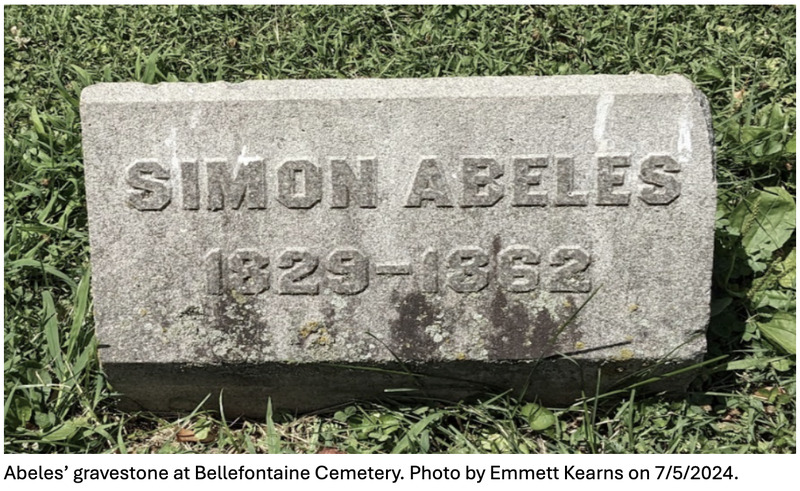
Simon Abeles lived from 1829 to 1862. He moved to Missouri in 1844, two years after his brother, Adolph Abeles. Simon is recorded as a landowner on plat maps of the current-day Tyson Research Center in 1862 and 1870. While Simon did not marry or have children, he was part of the Austrian Taussig-Abeles family group. These two families were intertwined by frequent marriages.
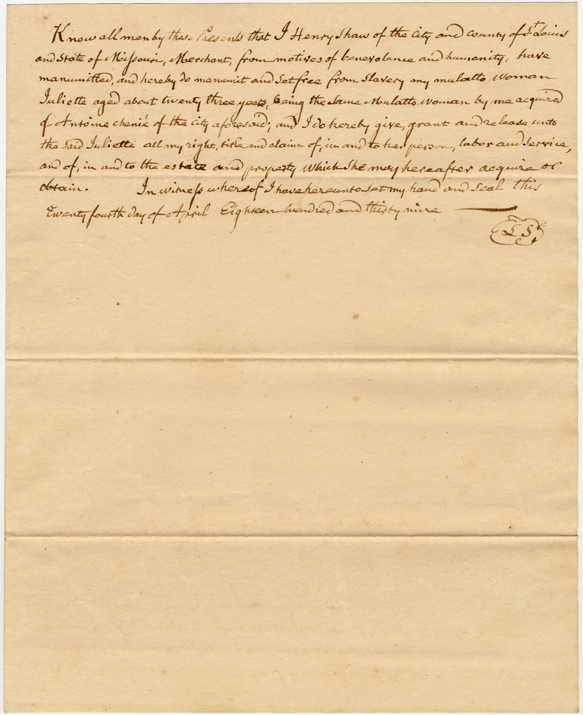
Sarah was sixteen years old when she and her four-month-old son were sold at a public auction the entrance of the St. Louis courthouse to settle the estate of their deceased enslaver, Eliza Brown. Henry Shaw purchased them at this auction for $600 on October 16, 1850.
According to plat maps, Samuel Byrnes (1791-1863) owned land that is today Tyson Research Center in 1862. His son, William C. Byrnes, is documented as a landholder on an 1870 plat map and likely inherited the property. The Byrnese family is the namesake of the Burns-Stuart Cemetery on the south side of the Tyson property.
Robert Johnson served as president of the Association of Black Collegians (ABC) during the pivotal 1968 campus protests. He authored the “Black Manifesto,” a document demanding institutional accountability and the creation of a Black Studies program at Washington University. His leadership during the sit-in helped bring about lasting change, including the establishment of African and African American Studies as a formal academic program.
This document details the legal proceedings of a fugitive enslavement case in St. Louis, Missouri, dated October 21, 1850. Presided over by Judge Alexander Hamilton, the case involves the escape of an enslaved man named Bill, who fled from the enslaver Andrew G. Gist in the spring of 1850. The record provides a description of Bill and certifies his status as an enslaved man under Missouri law, as well as the legal steps taken by Gist to reclaim him under the Fugitive Slave Act of 1850.
Receipt from bounty hunter, Bernard Lynch to Henry Shaw itemizing costs incurred boarding captive enslaved persons, Sarah and Esther. Costs incurred arresting Esther and her subsequent sale to John D. Fondren of Vicksburg for a total of $350. Dated July 30th, 1855
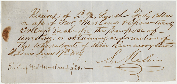
Receipt of payment to bounty hunter, Bernard Lynch, on behalf of Mr. Moreland and Shaw 20 dollar each for information, tracking, and return of their escaped slaves (assumed to be Sarah and her child). Dated June 17th, 1854 and signed by a S. Meloin. The document itself doesn't seem to mention Sarah or her child's name.
Receipt from bounty hunter Benard Lynch for $100 to Henry Shaw itemizing costs incurred capturing enslaved person, Esther in Illinois and returning her to Saint Louis. Dated May 21st, 1855.
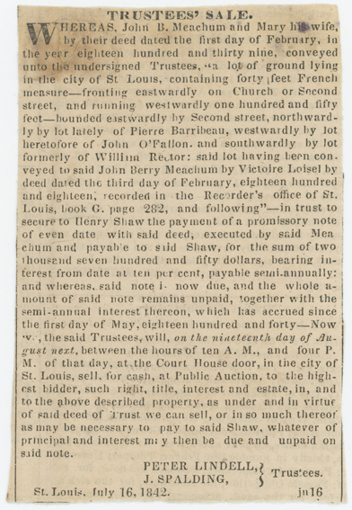
This is a purchase receipt for Henry Shaw, paying for the newspaper advertisement of John and Mary Meachum's Trustee's sale of property. The cost was $15.00. The purchase was submitted to the newspaper *St. Louis New Era* Office, to C.G. Ramsey (assumed to be Charles G. Ramsey, the owner of the St. Louis New Era Newspaper) and Geo. Brownfield.
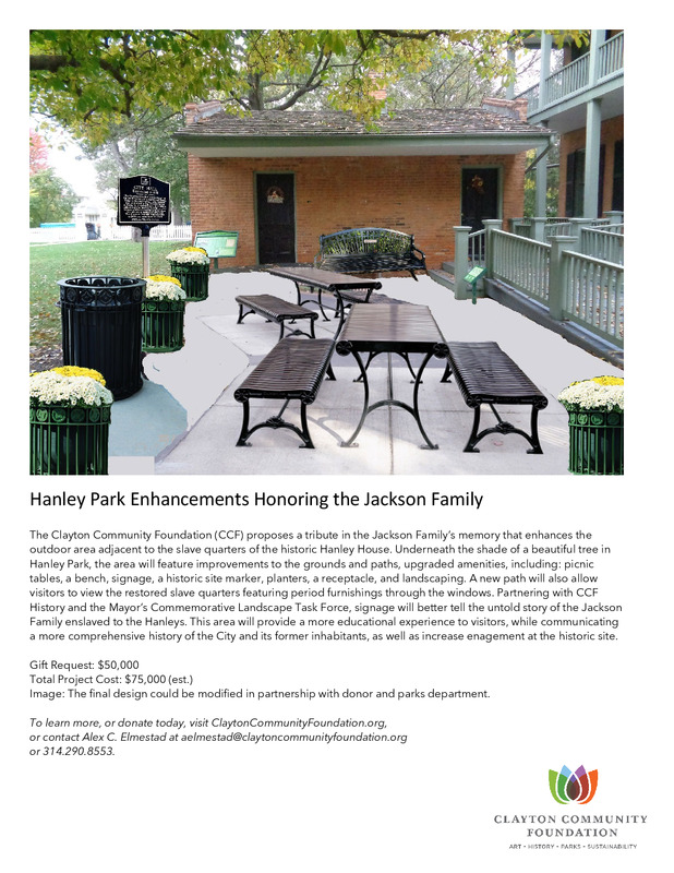
Clayton Community Foundation's proposal to tribute the enslaved Jackson Family's memory at the Hanley House. Would include improving landscaping, paths, and the outdoor area where the slave quarters were.
Phillip Kais (1820 – 1912), a farmer from Germany who moved to Bonhomme Township, Missouri, held land at what is now Tyson Research Center according to plat maps dated 1878 and 1893 alongside Christian Morschell, who was a prominent businessman at the time. They may have been interested in the land along the Meramec for the purpose of sand and gravel mining, which was Morschell’s area of business.
The Helderbrands were among the earliest settlers of the St. Louis area, arriving in the mid-18th century. The family had previously resided in Pennsylvania since the early 1700s, and their legacy is marked by generations of aggression towards Indigenous people in Pennsylvania and, eventually, Missouri. Over the course of his life, Peter Helderbrand acquireda significant amount of real estate, including a parcel of land within the property that would become Tyson Research Center. Most of his land was sold after his death.
Henry Shaw purchased Peter, also known as Peach, from J. H. Dodge of St. Louis in 1828; the bill of sale contains an annotation that Peach died at a later, unrecorded date. From June 1840 to October 1842, Shaw rented the labor of Peach and Bridget to Robert Lindell.
Alphonse Netmore (or Wetmore) is the Justice.
Charles G. Ramsey, a prominent newspaper publisher at the time, provided the affidavit.
The trustee's sale of property to John and Mary Meachum is being published in the newspaper titled 'St. Louis New Era'.
This is a newspaper advertisement of the Trustees' Sale of John and Mary Meachum's property in 1842, due to their inability to pay off the loan from Henry Shaw. The advertisement describes the location of property.
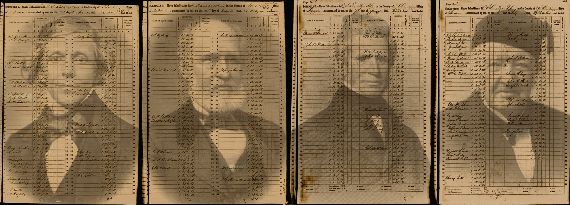
Nelson Tindall (b. 1761), who owned land on what is now Tyson Research Center property according to plat maps from 1838 and 1846, was an enslaver. The 1850 U.S. Federal Census Slave Schedule, District 82 records Tindall enslaving seventeen people. For a time Alvin Aaron Coffey, who traveled with a previous enslaver to California as part of the Gold Rush, was enslaved by Mary and Nelson Tindall, from whom Coffey purchased his freedom in 1854, and his family's freedom in 1857, from the gold he acquired in California.
Three generations of the Mincke family held land on what is present-day Tyson Research Center. They appear on plat maps of present-day Tyson from 1870 until the federal government obtained the land in 1941. The Mincke family left a significant mark on the land, and the remains of the town and quarry cave from their limestone mining operation exist on Tyson’s property to this day. An 1870 plat map reports brothers George Ferdinand Mincke, Jr. (1829 – 1905), and Julius Henry Mincke, Sr. (1826 – 1887) as landholders at what is now Tyson. In 1877, they began operating a limestone quarry on their land at Tyson, establishing the small town of Mincke where the workers and their families lived. The mine ran until 1927, at which point the fifty-year lease expired and the mining company moved on. During and beyond the fifty-year lifetime of the Mincke Quarry, the land passed through different hands within the Mincke family. In 1893, a Jos. H. Mincke appears on a plat map. This is believed to be George F. Mincke’s daughter, Josephine, (1868 – 1966). Josephine, a schoolteacher, was also a secretary at the family company in St. Louis, Mincke Monolithic Products, which produced granite products such as headstones, lampposts, and retaining walls. Julius Henry Mincke’s son, Henry Julius Mincke (1866 – 1953), appears as a landholder on a 1909 plat map of the area that is now Tyson Research Center. Henry owned several farm and gravel properties on the Meramec River. In a 1930 plat map, Henry’s son, Julius Henry Mincke Jr. (1900 – 1982), is listed as the landholder.
A memorandum dated 1 May 1840 for a two-year extension of the $2750.00 loan agreement between John Berry Meachum and Henry Shaw was issued on 1 February 1839. The memorandum states that Meachum paid the interest on the loan from February 1st, 1839.